Explore QLD
16 Jul 2022
Gallery40
The name Coen got on the map early when Dutch navigator Jan Carstenszoon, the commodore of a Dutch expedition, named the Coen River in 1623.
He was in charge of two ships, the Pera and the Aernem, out of Batavia, Dutch East Indies. However, his ‘Coen River’ was south of Pera Head – between Thud Point and False Pera Head – north of the Archer River, which was named by Frank Jardine in 1865. The original Coen River is marked as Norman Creek on some maps.
The (South) Coen River was bestowed by latter-day explorers for reasons unknown. It came to light when a prospecting party of 15 men split in to three groups near the present township of Coen in September 1876.
One group, which included Robert Sefton, James Watson, John Russell, Sam Verge and a man called Goodenough, discovered gold on Lankelly Creek. They built a ‘fort’ as protection against the natives, but managed – between dodging the long spears – to take 60 ounces of gold to Cooktown in December. The men returned after the wet season and were back in Cooktown in December 1877, this time with 140 ounces.
It started a small rush, but the alluvial gold had petered out and the field was abandoned. Others persevered, and in 1887 the Wilson battery employed 40 men crushing ore from the surrounding ‘shows’. Other mines were also worked including the Great Northern, which in 1904 was labelled ‘the greatest mine in the State’. It was the mine that put Coen on the map as a township.
40
Mining towns have always had fluctuating fortunes and resultant populations, and Coen perhaps more than others. Several mines were about the town and farther afield on the Stewart River in the south and the Wenlock River to the north.
The arrival of the Overland Telegraph Line in 1884 placed Coen on the map as a telegraph station, while spasmodic gold-finds kept people searching – even today’s modern prospectors armed with metal detectors still find Coen gold.
Cattlemen with herds also arrived and Rokeby Station and others were founded. The influx of whites displaced the natives, some who found work at the mines and the stations. While much of their traditional lands have been returned, some 80 per cent of Coen’s population is indigenous who prefer to live in town.
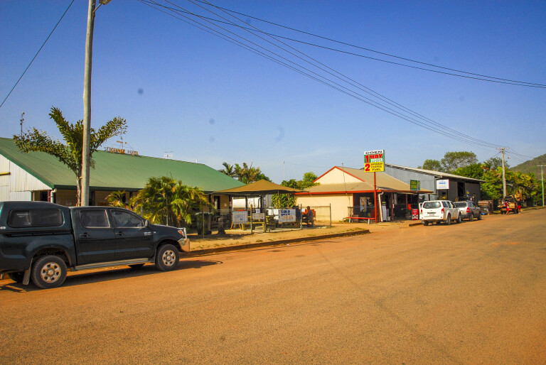
Coen has a police station; medical centre/hospital; two general stores that also sell fuel; RACQ garage; B&B; post office with CBA agency; EFTPOS facilities; internet service; hotel; a café; town and bush camping areas; national park office; airport; and the Information & Inspection Centre 28km north of the town.
40
Coen’s history and other memorabilia can be seen at the Cape York Heritage House – the former telegraph station – while interesting old mining equipment is stored next to the police station.
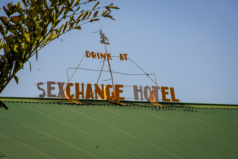
An essential stop in town includes having a drink at the (S)Exchange Hotel, which had the letter S added by a graffiti artist sometime back and is now widely known as such. Other highlights include self-guided walk, drive and cycle tracks; historic buildings; mine ruins; the local bird-rich dam; and the rest area site, which makes a stopover interesting.
You can also swim and camp 3km out of town at The Bend. The town is surrounded by high hills that provide a nice backdrop when compared to the monsoon woodlands of the Peninsula Developmental Road.
The name Coen may soon vanish from the maps as there is a move to have the town renamed to an Indigenous name, Moomba. The same is happening to other pioneering names as the whole of the Cape is being returned to its traditional owners, either by land rights claims or through direct purchase by the Queensland Government and gifted to them. Some 360 people live in Coen.
Port Stewart
The 63km Port Stewart turnoff is 28km south of Coen (or 80km north of Musgrave) on the PDR. It’s a scenic drive across the McIlwraith Range. The once very steep decline in to the Princess Charlotte Bay lowlands (24km from the PDR) has been tamed and a new and much safer road decline was completed in December 2009.
En route is the turnoff (20km) to Aboriginal-owned Silver Plains Station. The station has camping sites on the Massey River, a boat ramp and good fishing. Some boar hunting with a local guide is possible when available.
40
Be aware that things can change daily with access on Indigenous lands, and permissions can get cancelled at the whims of an elder, or death in a family.
Port Stewart, once the supply centre for its hinterland, only attracts anglers these days who take advantage of the fishing and mud crabbing in the Stewart River estuary and the Yellow Zone (recreational fishing only) strip that borders the coastline.
There are camping sites and boats for hire from one of the rural properties nearby. There is no freshwater available.
Oyala Thumotang National Park
Rokeby Station and Archer Bend Stations were settled in the 1880s and purchased by the Queensland Government for National Park purposes in 1977 and 1981 respectively.
They were amalgamated in 1994 under the names of the two Aboriginal tribes for the country – Mungkan on the western side and Kaanju to the east, and the park named Mungkan Kandju. However, the whims of traditional owners are ever changing, and the park is now called Oyala Thumotang. It is jointly managed by the traditional owners and the Queensland National Park Service.
The park headquarters is on the northern end of Coen – opposite the Telstra tower that lords over all. You can get dated details from the helpful staff if you plan to visit the peninsula’s fourth largest park, which at 4570km² is one of the least visited parks in Queensland. The eastern section of the park is part of the Kulla (McIlwraith) Range, and Mount Kroll at 488m dominates the range. The Coen River and several creeks rise in the range and run in the Archer River farther west.
40
Verdant monsoon rainforests cover the cool, moist heights of the McIlwraith Range to the east. Watercourses rising from the heights have fringing gallery rainforests that are important wildlife corridors, allowing animals to move in to the drier western regions. The scenic and biological values of these narrow stream lanes are of great interest, especially during fruiting season when myriad birds bring the rivers to life.
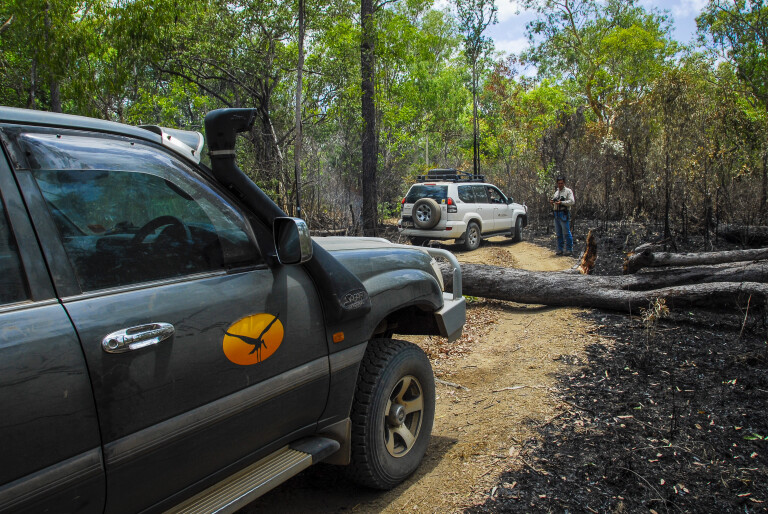
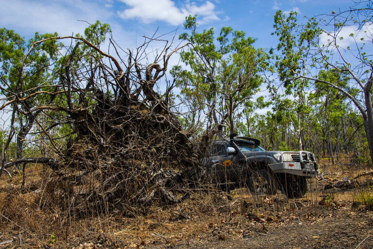
The eastern section of the park has many 4WD-only tracks that end at waterholes and old mines, while the main western entrance is about two kilometres north of the Information & Inspection Station. It’s a pretty drive through low woodland and scrub before crossing the Geikie Range, where sweeping vistas extend to the Coen River valley.
Oyala Thumotang National Park is arguably the best wilderness escape on the Peninsula
About two kilometres before the junction of Merapah and Rokeby is a turnoff that ends at the 10-Mile Junction on the Archer River and farther downstream at Old Archer Crossing. The park is well-signposted and there’s no chance of getting lost.
There are several billabongs en route, called lagoons on the peninsula – misnamed according to the dictionary, as a lagoon is a tidal-influenced body of saltwater, while a billabong is Australian slang for an oxbow lake which is filled by the overflow or by flooding of a freshwater stream. Along the track are Night Paddock, Langi, Bob’s and Twin Lagoons. The track runs through relatively flat monsoon woodlands and scrub.
40
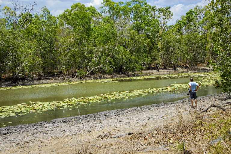
The country is predominantly dry, open monsoon woodland with seasonal wet melaleuca swamps and perennial billabongs scattered about in low areas. The shallow swamps are truly magical just after the wet season, when their surface is alight with colourful water lilies, interspersed by the bright red blooms of the freshwater mangrove.
Both 10-Mile Junction and Old Archer Crossing are great destinations, where you can camp under shady verdant monsoon gallery rainforest that fringes the river on both sides. It’s a haven for birds, where the morning chorus of myriad bird voices is like nowhere else.
Endemic birds like palm cockatoos, eclectus and red-cheeked parrots, Marshall’s fig parrots, magnificent riflebirds, trumpet manucode and others may be seen and heard along the beautiful river during the fruiting season from September. The billabongs are alive with waterfowl – ducks and geese, darters, cormorants, herons, egrets and jabirus – while woodland birds – honeyeaters, finches, doves, and pigeons – abound about the waterholes.
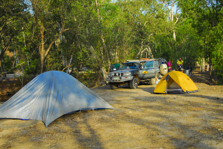
There are no organised campgrounds in the park – just find your own spot on one of the billabongs or along the river. There are also absolutely no facilities, so if you ever wanted to bush camp on your own on the Peninsula, this park has so far gone unnoticed by the annual invasion of dry-season visitors.
The fishing is excellent for sooty grunter and saratoga, while the big wet-season floods restock barramundi – and saltwater crocodiles – in to the park’s permanent billabongs and pools. Of course, if you are an angler you already know the best fishing is after the wet season when the park first opens.
Western sector
Follow the main Merapah Road, across the bottom end of the Rokeby airstrip, and take the marked turnoff to Vardon’s and Archer Bend camping areas. The route takes you in to the western segment of the park, which is separated by a grazing lease and stock route. The track ends on the banks of the verdant Archer River where two large permanent pools, Horsetailer and Governors Waterholes, have good fishing and bush camping.
En route are several sidetracks that end at swamps, billabongs and some Coen River waterholes. The Coen River has a better flow than the Archer, and there are many permanent pools that never dry. In line with the Archer, there is much gallery rainforest, though it is not as verdant.
The fishing for barramundi, saratoga, sooty grunter, cat and archer fish is excellent, and if you have a fishing rod you won’t get hungry here. Chong Swamp and Vardon’s Lagoon are swamp wetlands alive with birds, while other marked tracks end up at deep pools in the river and creeks. Both dry.
40
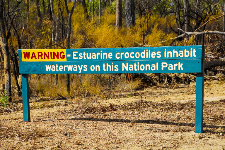
Most of the billabongs and the lower Archer River pools are suitable for tinnies, and the Coen can be fished from the banks as it is not very wide. Avoid using canoes and kayaks in the crocodile-infested Australian tropics, especially anywhere on the peninsula. A canoeist was killed by a five-metre crocodile in Rinyirru National Park some years ago. The park has a good population of both fresh and saltwater crocodiles, with the latter as much at home in freshwater as it is in salt.
If you want to avoid noisy crowds that plague most Peninsula camping grounds, then Oyala Thumotang National Park is arguably the best wilderness escape on the Peninsula. It may not be scenic or pretty, but as a pure wilderness getaway it’s a place where you can sit and look up at the stars, wake up to the dawn chorus of birds, or fish in tranquil waters where only the flapping of vociferous waterfowl disturbs.
The park is an essential stopover on any Cape York discovery trip, if you want to experience the wilderness or just need another reason to return to the Peninsula.
Top 5 things to see and do
01: Coen Information and Inspection Centre
Australia is free from many world-wide diseases, and with the tip of the Cape only a short boat ride to New Guinea some pests have arrived from there and become established. So, you can take fruit north, but you must dump it in bins at the quarantine station, 21km north of Coen, when returning south. While you don’t have to stop on the way north, do visit the Information Centre that is part of the complex and get a free Cape York Information Kit.
02: Bird-watching
Immerse yourself in an avian wonderland. Endemic birds include palm cockatoos, eclectus and red-cheeked parrots, Marshall’s fig parrots, magnificent riflebirds, trumpet manucode and others. The billabongs are alive with water ducks, geese, darters, cormorants, herons, egrets and jabirus; while in the woodlands are honeyeaters, finches, doves, pigeons and more.
03: Coen capers
Have a drink at the (S)Exchange Hotel, the letter S added by a graffiti artist sometime back. For getting around town try the self-guided walk, drive and cycle tracks; visit historic buildings, mine ruins, the local bird-rich dam, and the rest area site. You can swim and camp three kilometres out of town at The Bend.
04: Fish and boar
Like the Top End and Kimberley, Cape York rates as a top tropical fishing destination. Target species include barra, sooty grunter, saratoga, and mud crabs. Aboriginal-owned Silver Plains Station has campsites on the Massey River, a boat ramp and good fishing, while some boar hunting with a local guide is possible when available. Most of the billabongs and the lower Archer River pools are suitable for tinnies, while the Coen can be fished from the banks.
05: Ultimate getaway
Oyala Thumotang National Park at 4570km² is Cape York’s fourth largest NP, but the least visited. The eastern section includes the Kulla (McIlwraith) Range and 488m Mount Kroll, the Coen River and several creeks rise in the range that run in to the Archer River farther west. The park is well-worth the visit, particularly if you want to escape the maddening crowds found elsewhere.
Travel planner
Oyala Thumotang National Park
Phone: (07) 4060 1137
Web: parks.des.qld.gov.au/parks/oyala-thumotang/camping
ACCOMMODATION
- Exchange Hotel (units and budget rooms)
Phone: (07) 4060 1133 - Homestead Guesthouse (B&B)
Phone: (07) 4060 1157 - Armbrust General Store (units and small campground in town)
Phone: (07) 4060 1134 - The Bend Campground (2km north of town): Toilets only, free camping.
- Charlie’s Goldmine Campground (when operating): Past the refuse dump road.
- Silver Plains (check if operational): Call in and pay camp fees at homestead.
- Port Stewart (free campground): Located near the boat ramp.
Please enable JavaScript to view the comments powered by Disqus.
COMMENTS