Explore TAS
27 Sep 2022
Gallery46
Tasmania is full of stunning scenery, has an array of history and some bloody great four-wheel driving to boot. I wanted to try and get to the NE corner of the state on this trip from Hobart totally off-road, and with a few snippets of local info, I did just that.
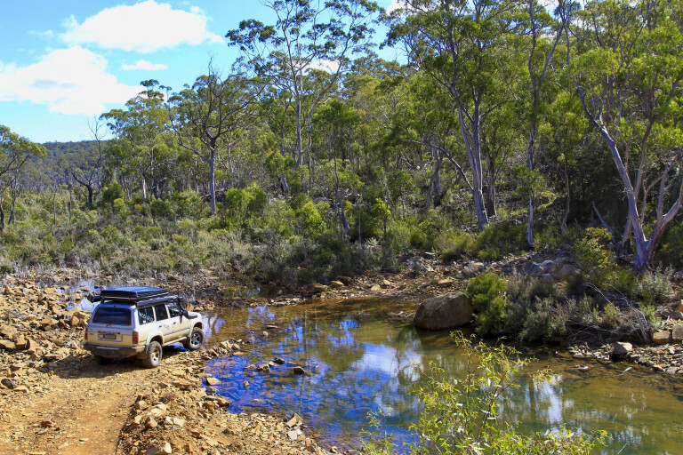
My starting point was Sorell, just out of Hobart, where there’s plenty of decent supply shops for food and fuel. I was given a tip that if I headed 20km up the Tasman Highway and found Woodsdale Road, that’s where I could hit the dirt and stay there to the cape – and an easy and scenic run up to the bitumen to the turn point got me in the groove for the trip. Woodsdale Road is a well-used dirt road that feeds farms and a few wineries, and it leads in to the forest; nevertheless, I was on the dirt for the journey.
46
Passing alongside Prossers Ridge line and turning across towards Mount Hobbs it was the typical bush I was used to on the mainland, with great views and growing anticipation of what was in store for the next few days.
Swanston
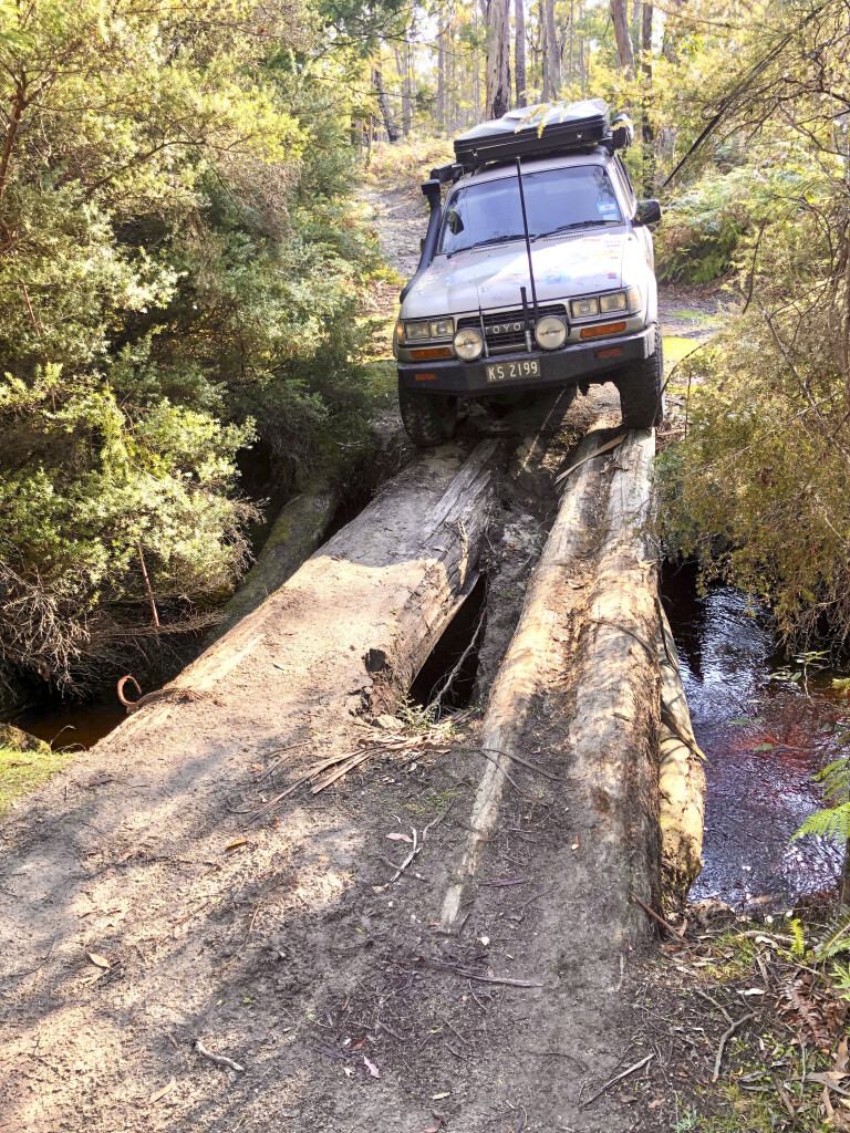
A local told me about the Swanston Track and where it followed the northern side of the Buckland Military Training Area, and it’s a pretty easy track to find at the end of Swanston Road. It was interesting that where I crossed Little Swanport Creek was the old convict transit town of Swanston. These days, it’s nothing more than a sign indicating that it was here back in 1830, that convicts where rested on their way from Little Swanport inland to Oatlands some 40km farther west. Oatlands has more than 150 sandstone buildings and is one of the oldest settlements in Tassie.
46
How’s this for a bridge ... steady as she goes!
The Swanston Track is around 30km long and is a great challenge in the dry as it follows the military property, but you need to adhere to all the warning signs along the way. The track is regarded as hard and you need to allow up to three hours as it’s a combination of steep rocky climbs and bog holes, with several steep switchback creek crossings thrown in. I won’t say that it was too hard but I wouldn’t recommend it for a soft-roader as you’ll need some decent ground clearance and proper low range.
The track ends at Little Swanport, where I had to head north on the Tasman Highway for just 5km before turning left on to McKays Road. A lot of dirt roads in Tassie are working roads and this one was no different with logging operations underway, but in most cases the main roads are open with care.
46
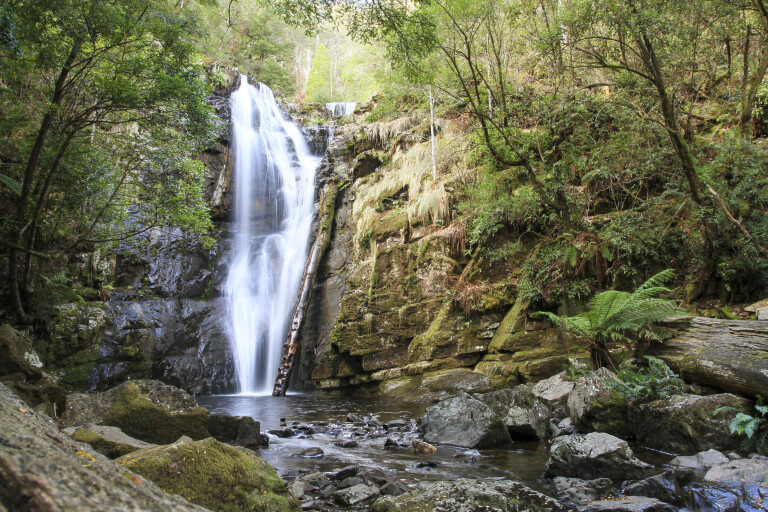
Chasing waterfalls
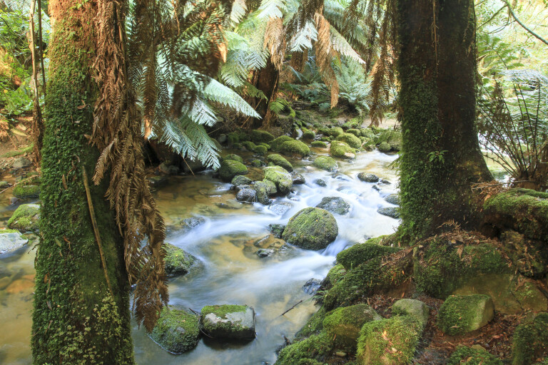
A highlight of Tasmania is the vast amount of waterfalls due to the high rainfall and the island’s steep terrain, and one I discovered was Lost Falls about 50km along McKays Road. It’s a 10-minute walk from the car park but it’s well-worth the effort, as the water tumbles over several drops to weather away the basalt rocks. Crossing over the Leake Road intersection back on to the dirt, Meetus Falls was another port of call and a blast of a stopover – it’s one of the taller waterfalls on the island, along the Cygnet River.
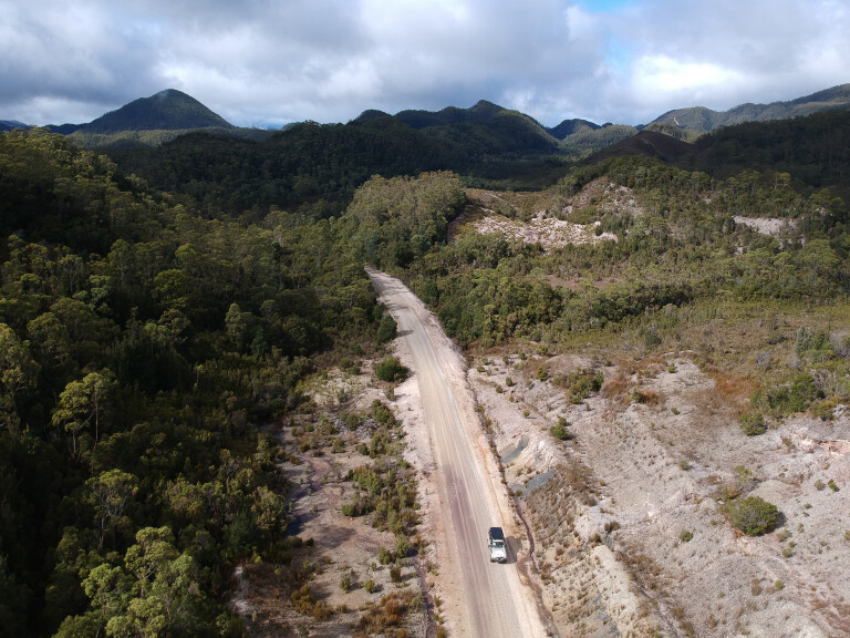
McKays Road continued on for about 60km, with Douglas-Apsley National Park on one side and pine plantations on the other. There are tall peaks in every direction, and you’ll need wheel chains in winter due to the icy roads.
46
At the end of McKays Road I took a left on to Valley Road, and once again mountains lined the route until they gave way to the Break O’Day Plains, where rich farmlands mimicked something out of an English movie. Imagine stone walls and twisted trees used as windbreaks allowing the livestock to graze in the thick, green paddocks.
I had to turn right on to Main Road – a short 11km tar section – before heading north to Barnes Road and farther north to Evercreech Road and Mount Albert Road. These great, narrow roads are lined with plantations of cyprus pine and blue eucalypt forests, grown for sustainable harvesting.
46
Pub in the paddock
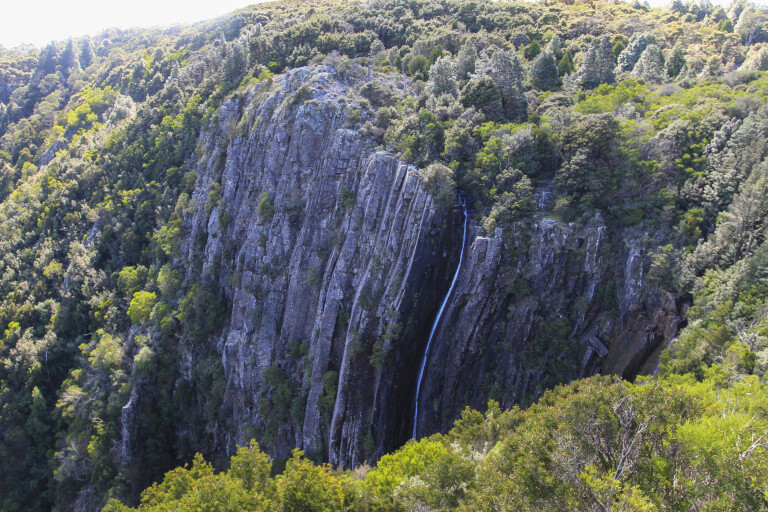
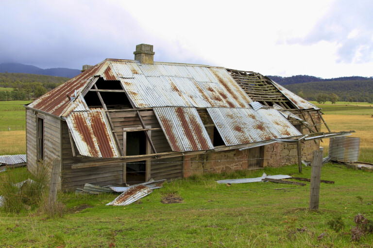
Just near Pyengana is St Columba Falls, the second tallest in Tassie with a single drop of 90 metres – and I wasn’t disappointed following a short walk along a tree-fern lined pathway. The valley here is rich in history that dates back to 1875, when the Cotton family (mum, dad and 10 kids) settled to set up life as farmers. The story goes that their boys were more invested in drinking than farming and, as the years went on, the town grew and more people socialised at the family home. So instead of building a hotel, the boys simply licensed their family home as the Columbia Falls Hotel, known today as the Pub in the Paddock. If you read the signs near the falls and follow the directions, you can still see remnants of the 45km water race that was used to get water to the tin mine near St Helens.
Leaving Pyengana via the highway, I headed up Anchor Road towards Lottah. On the way I stopped at Halls Falls, which didn’t disappoint with its wide drop over the rocks. Just above the falls is a man-made weir created when Chinese miners worked tin during the 1880s.
46
One of my goals on the trip was to find the Anchor Stampers and, following the rough map near Halls Falls car park, it’s another 30 minutes up the road through Lottah. This area was so rich in tin that by the mid-1800s it was regarded as the largest in the world, with locals calling the place ‘The Mountain of Tin’. A short walk to the stampers had that wow moment, leaving me shaking my head after reading of the achievements and history of the district.
The Anchor Mine Company had the largest water wheel in Tassie – 20 metres in diameter and around 20 tonnes in weight – but the water supply was inadequate to operate it at full speed and it could only run 30 of the 40 stampers. Over the years, the mine had several owners with varying degrees of success.
46
In 1904, aerial haulage replaced the horse-drawn system up to the other mines above the processing plant, but 10 years later the mine closed. Further attempts to reopen the mine up until 1996 have been trialled, but they failed to produce a profit. The last owner couldn’t remove the last two stampers and they were left as a memorial.
Along the walking track you can still see old trolley carts, wheels and one of the dams. Up the road, Blue Tier Reserve was once the mining hub where a small town called Poimena survived. After tin was found, the thick rainforest was cut down and creeks were sluiced for the water – but tin soon began to run out and by 1954 the last building was moved to St Helens.
46
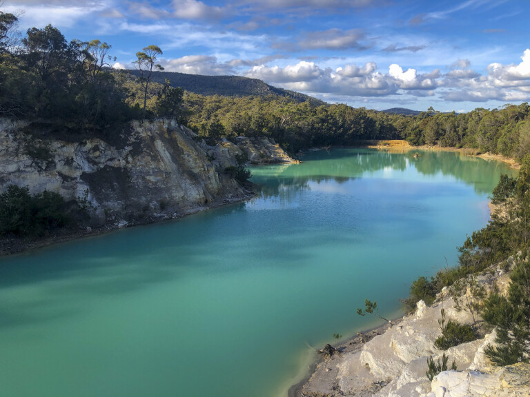
Little Blue Lake
Counsels Road that leads north from Poimena soon turns in to Tebrakunna Road, and they’re both good touring dirt roads. My goal was to stay on the dirt all the way to Cape Portland, but I heard of an unusual blue lake nearby – so at the end of Ogilvies Road, I trundled along Gladstone Road to the Little Blue Lake. The lake was once a tin mine that littered the area but has since been filled with water and can be accessed for swimming (not advised) and kayaking. The iridescent blue colour is from the rich minerals in the white clay that line the lake’s shores and base.
Back to the dirt and it’s an easy drive through the forest following the Great Musselroe River, and even through here there’s evidence of the mining days with deep open-cut mines and relics. At the end of the road you can either turn towards the east coast or head to the top of the state. The trip to the east coast and Mount William National Park is a good hour-long trip through farmlands until you enter the park and, by heading out along Eddystone Point Road, there’s more history to explore. Back in 1642, Abel Tasman sighted this coastline but couldn’t map it correctly due to bad winds and rocky outcrops. It was the late 1800s when the lighthouse was finally built from local pink granite, along with several cottages.
46
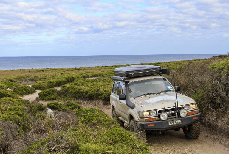
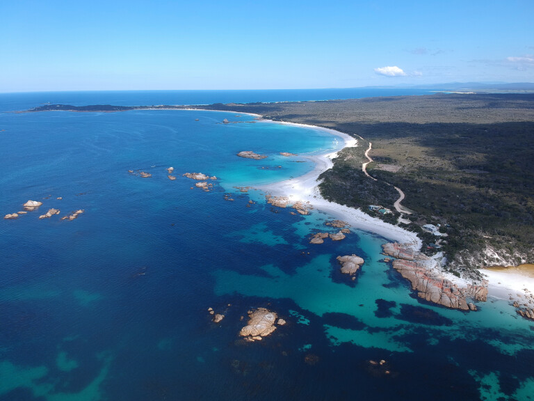
Heading north to Cape Portland the road traverses typical coastal plains with windswept trees leaning to one side and low-growth scrubs that have adapted to the conditions. Midway to the top, Rushy Lagoon farm holds most of the land. This mega property runs thousands of sheep and cattle and has a small community to manage it. Also dotted on the landscape are several wind farms. At the end of Cape Portland Road the camping at Petal Point is pretty special, with windswept ocean views toward Bass Strait, and beach access along Ringaroomba Bay. On the eastern side of the Cape, camping is permitted at the Little Musselroe Bay area at the entrance to the Little Musselroe River.
After a little local knowledge and digging around with some maps, I managed tackle the Hobart to Cape Portland off-road drive. It’s a trip that can be done on the bitumen in just five hours, but off-road it’s a four-day journey seeking out waterfalls, mine relics and maritime history. I just wonder what else I missed.
46
Five things to see and do
1. Oatlands
Some 80km north of Hobart on the Midland Highway is the historically important town of Oatlands, containing Australia’s largest collection of sandstone Georgian buildings. The town was established around a military precinct in the late 1820s, with 150 of these mostly convict-built buildings still standing.
2. Tumbling water
Blessed with abundant rainfall, Tasmania hosts plenty of waterfalls. Notable among the many cascades are the Lost Falls near Pyengana, the high Meetus Falls on the Cygnet River, and St Columba Falls 30km west of St Helens, one of the tallest.
3. Tin men
There’s no missing the influence tin miners have had on NE corner, with plenty of info highlighting the industry’s old points of interest such as the remants of the Anchor Stampers a few kays from the Halls Falls turn-off.
4. Little Blue Lake
Talking of tin, check out the flooded former Endurance Tin Mine near Gladstone. Now known as the Little Blue Lake, it gets its name courtesy of the bright-blue mineral-rich water. Officially there’s no swimming here, but apparently people do in summer. Hmm, you can have that.
5. Free camping
One of the great things about Tasmania is the amount of free camps, and along the way of this adventure there were plenty to choose from in the forest, lakeside or close to the coast.
Please enable JavaScript to view the comments powered by Disqus.
COMMENTS