Explore
12 Jun 2022
Gallery22
The Granite Belt in northern NSW is known for its wineries, Celtic culture and cool, crisp air. But did you know there’s a great drive where you can explore historical mines, spectacular scenery, checkout local bushranger hideouts along the way, plus great campsites tucked away?
With very cool winters on the tablelands and stifling summers, I decided to explore the region north-west of Glen Innes in early spring hoping for a little colour and to miss the extreme temps that frequent this area. Glen Innes is a funky little town with boutique gift shops, great bakeries, heritage-listed buildings and has most of the services that you would find in larger towns.
There are several tourist drives that run around the town, and a great drive is tourist drive number 11 but with a twist. After restocking supplies and fuel at Glen Innes, the road north-west towards Emmaville is a nice introduction to the area’s wonderful grazing land. It’s a typical English-looking area with tree-lined windbreaks defining fence lines, sheep-filled paddocks, plus boutique wineries offering tourists wine tastings. The road to Emmaville is tar for its 40km length, but as it leaves the flat fertile grazing land it twists and weaves its way over several ranges where you need to be on the lookout for feral goats, ’roos and deer beside the unfenced road.
22
At the end of the Mount Mackenzie Lookout Road are sweeping views and picnic area with a gas barbecue
Getting closer to Emmaville you will come across the Y Waterholes (yep, that’s their name!) that grace both sides of the road. These waterholes are from the nearby lead mine, now closed. Over time, the water has become safe for the birdlife to inhabit its waters and shoreline, from swans, wild ducks, ibis and a host of other birdlife and is a nice change from the dry forests nearby. Farther down the road you come to the once booming town of Emmaville. Several places are worth checking out here, the mining museum (only open mid week), the Emmaville lookout, the tin church and several old graveyards where headstones date back to the 1800s. There is a general store and fuel if you really need to top up.
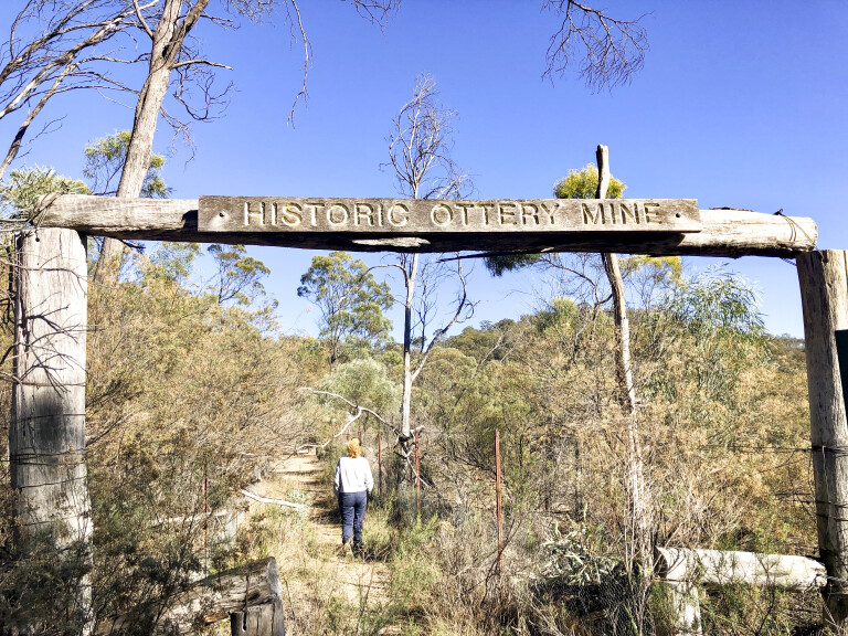
Ottery Mine
Following the tourist drive out of town for just 5km, a turnoff will appear to your left towards Torrington. This is where we leave the tourist drive and the adventure begins. The landscape out here is harsh, scattered dry timber with granite boulders dotting the landscape.
It’s pretty easy to miss, but just 6km along, the road narrows and passes through a gate and across a grid. Not signposted but this is where you need to turn left to explore the old Ottery mine. The formed track will lead you to an open area where there is plenty of parking for 4WDs.
22
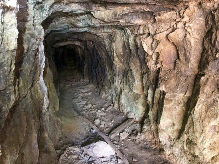
Adhering to the warning signs at the beginning of the track (no collecting rocks or going past the fences) it’s an easy stroll in to the old arsenic mine and historic Ottery tin-mine site. The Ottery tin mine was one of the first underground base metal deposits in the area. It was worked from 1882 till around 1905 and produced an estimated 2500 tonnes of tin concentrate, plus 2004 tonnes of white arsenic. Several attempts were tried to reopen the mine up to 1957 with no success and due to the import of cheaper arsenic, the mine finally closed.
Exploring the old mine area here is great, as you can wander around freely where you can see old relics such as mine buckets, the main shaft that is 80m deep, the large chimney flue, cooling chambers, furnaces and more.
22
Interesting to note that white arsenic is still leeching out of the workings. Arsenic was used for a variety of purposes at the time, from the control of prickly pear as well as an important ingredient for many animal health products such as sheep dip. After the mine closed, it was left in a very damaged state with open mineshafts and obviously a few health risks with open waste dumps. Rehabilitation work was carried out by NSW DPI making the site safe to explore from behind fences and is now an important historical site.
This is a great place to lose an hour or more following the path around the mine, reading the information boards and imagining just how life was out here over 100 years ago. Back through the gate, the tar winds its way for around 5km on to the dirt for an easy 30km drive towards Torrington.
Captain Thunderbolt
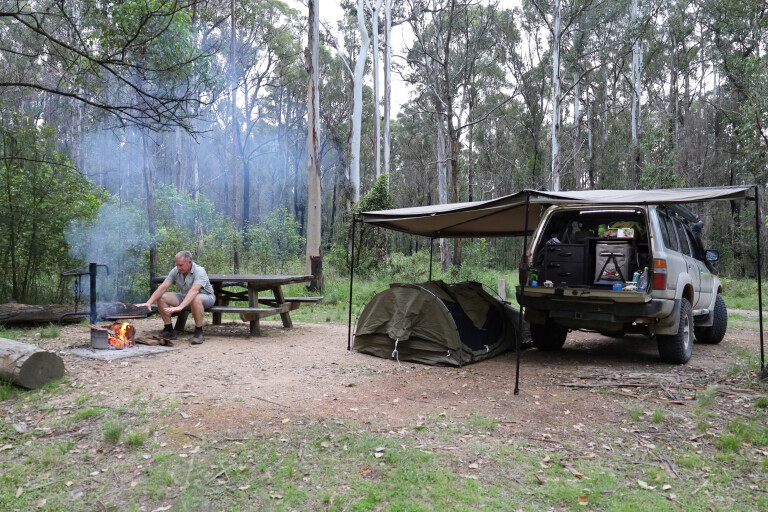
As you approach the outskirts of Torrington, keep an eye out for Dutchmans Road on your left, this will lead you to the Nomads camping and picnic area. While great for a tent or two, this camping area is really designed for more of a stopover than a camp, and you can take the short walking trail to one of Captain Thunderbolt’s hideouts.
22
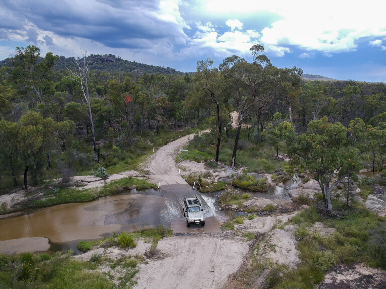
There are plenty of nice camping options along the way
Captain Thunderbolt was known to have roamed the area from Uralla in the south to Tenterfield in the north. Along the path, the granite boulders can only be described as huge as they have sat for thousands of years. The path will soon lead you to formed steps that wind there way up through the boulders and soon disappear in to the abyss. As you sneak between the rocks you can see why the bushrangers used to hide in these areas, it would of been a great spot to hide and to find a higher peak to keep an eye out for approaching authorities. The walk leads you through dark sections between the rocks eventually ending at a steel ladder that’s near vertical for 10m where you can stand safely on a platform giving you 360-degree views to the horizon.
Heading back to Torrington, you’ll find this town is near deserted with only a handful of houses still occupied. Mining activity peaked here around the 1920s when Torrington and nearby villages served about 600 miners. Torrington was a bustling town with five general stores, a butcher, baker, courthouse, police station, post office, two churches and a hotel. Nowadays there are no facilities and no services, but surprisingly there is a limited mobile phone reception if you stand the right way.
Torrington SCA
Leaving Torrington along Silent Grove Road, it’s a short 15-minute drive to a great camp area as you enter Torrington State Conservation Area, a sign will point you to the right just 2km out to Batherarm camp ground and picnic area. There are great facilities, with each camp area having its own pit toilet, tables and a water tank. Watch out for mineshafts and workings, they are everywhere, as this section is known as a dedicated fossicking area where you can find several types of crystals, gems and minerals. There are three camping areas, aptly named 1, 2 and 3. The first two have easy access but camping area number three is across the creek and you will need a four-wheel drive, especially if towing a camper trailer. The creek doesn’t get a lot of flow but with a bit of traffic it can be a bit rough and bumpy.
22
Granite outcrops dot the way along the Upper Mole River Road
No bins are provided out here so you will need to carry all rubbish back out, this keeps the vermin away and the camp areas clean. A local information board gives you some great local history, wildlife rundown and an insight to fossicking in the area. The geological features and climate patterns are unique to the Torrington SCA and the surrounding tablelands providing habitat for more than 30 species of reptiles and around 13 native frog species.
Leaving camp is as simple as heading back out to the turnoff for a right-hand turn back on to Silent Creek Road, where granite cliffs and grunge rock sculptures tower beside the road. It’s hard to believe there was mining activity out here, but this area was known as The Silent Grove Nugget Mine, if you look closely throughout the bush you will see old workings, building foundations, massive open-pit mines now filled with mineral-rich water and even abandoned equipment. A dead giveaway are the signs trackside warning you of shafts in the area that you may fall in to.
Mole River
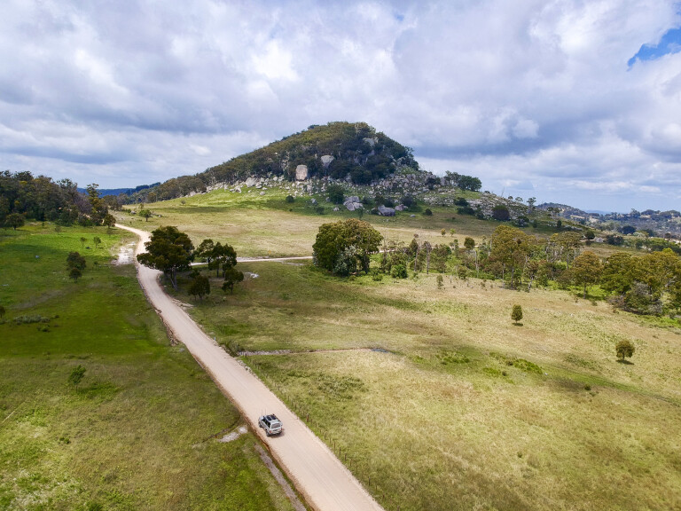
The landscape soon opens up, giving way to sheep stations and then cattle stations where mountain peaks and ranges start to appear, rising to near 1100m. The roads out here are narrow, sketchy and unmaintained as they twist over and down the other side of ranges towards Mole River.
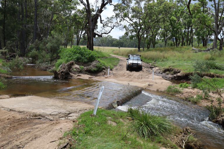
With the steep terrain out here, the Mole River can at times have some serious flooding, checkout the amount of debris in the trees high above and just how much bend the trees have in them from recent flooding. An interesting note out here are the low bridges you cross from time to time, this allows the debris to simply flow over the top and not destroy any bridge foundations thus not cutting off the roads.
22
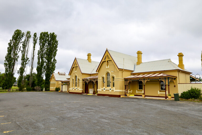
The heritage-listed Tenterfield railway station, now a museum, opened in 1886
A further 3km along, two options appear, either going straight on the tar to the Bruxner Highway, or turning right on to Upper Mole River Road which I did. As you keep going through Gunya Station there are some amazing granite outcrops around you, yet it’s hard to believe that you’re at 1000m above sea level. But be warned, in the winter months it can get a covering of snow so be prepared in the cooler months.
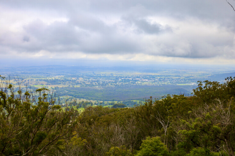
It seems everything blooms out here, plenty of wild goats, wallabies and ’roos, with prickly pear cactus and grass trees scattered amongst the rocks. A pleasant sight soon emerges and points you towards Tenterfield just 27km away along the Upper Mole River Road. It seems out here that there can be surprises just when you least expect them, like popping around another corner to be greeted with stunning views across another valley or massive rock formations. The road to Mount Mackenzie at 1300m high, gives stunning views over the Tenterfield area north to the Queensland border, and a great way to end a drive of the Granite Belt in northern NSW.
22
Top 5 highlights
01: Ottery Mine
The Ottery Mine is a heritage-listed former arsenic and tin mine where much of the infrastructure remains. This includes the former refinery, calciner, kilns, arsenic chambers and chimney stack.
02: Bushrangers
Captain Thunderbolt was a famous local bushranger of the northern New England region of NSW. Old Thunderbolt was famous for using the massive granite boulders as lookouts and places to hide in, which the walking trails in the Torrington SCA will point out.
03: Torrington State conservation area
The Torrington SCA spreads across the rugged Mole Tableland featuring dry forests and woodland mixing with scenic granite outcrops and boulders, gorges, swamps and small creeks. Notable are spectacular wildflower displays between September and March.
04: Camping
You can camp withing the Torrington SCA at the Batherarm campground and picnic area. There are three campsites within Batherarm, designated as 1, 2 and 3. Camp areas 1 and 2 are 2WD accessible, but getting to 3 requires a 4WD. Each camp has its own pit toilet, tables and a water tank. More info at: www.nationalparks.nsw.gov.au
05: Mount Mackenzie Scenic Lookout
At an elevation of 1300m, the Mount Mackenzie Scenic Lookout provides some spectacular views of the NSW Northern Tablelands and one of the places to see snow in winter. A great picnic spot, the lookout’s facilities include barbecues, picnic tables, picnic shelters and a toilet.
Please enable JavaScript to view the comments powered by Disqus.
COMMENTS